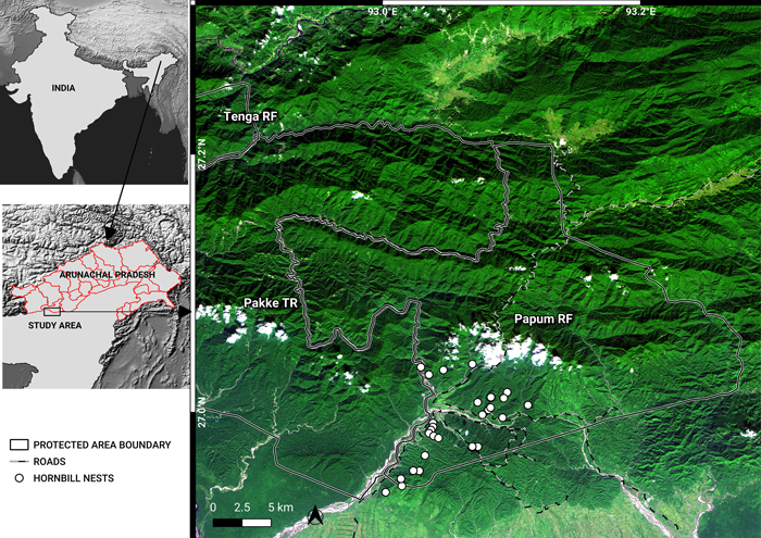
Fig. 1. A November 2018, false-colour composite image (RapidEye bands 3, 4, 1) of the study area, showing Pakke Tiger Reserve (TR), Tenga Reserve Forest (RF) and Papum RF. The administrative boundaries of Arunachal Pradesh are marked in the map of India. The border between Assam and Arunachal is also the lower boundaries of Pakke TR and Papum RF. Shades of dark green indicate forests in different elevations. Lighter green shades are cropland, secondary vegetation, flooded grasslands and bamboo. Whites are indicative of clouds, river beds and landslides. Blue depicts water. Notice the density of roads in the southwest of Papum RF. View larger in new window/tab.
| Table 1. Forest loss in the Papum Reserve Forest (RF), Khellong Forest Division, Arunachal Pradesh, north-east India. Forest loss was quantified using RapidEye data for 2013, 2014, 2017. The total area of the Papum RF that was classified was 737 km2. Numbers in parentheses indicate percentages (%). | |||
| Year | Logged-forest in km2 (%) | Forest in km2 (%) | Non-forest in km2 (%) |
| 2013 | 128.8 (17.5) | 593.8 (80.8) | 14.3 (1.9) |
| 2014 | 166 (22.5) | 556.5 (75.5) | 14.3 (1.9) |
| 2017 | 156 (21.2) | 561 (76.2) | 19 (2.6) |
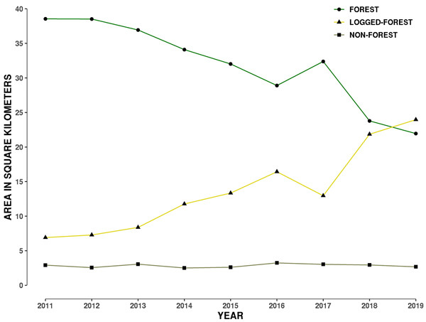
Fig. 2. Plot showing change in area of three land-cover types from 2011 to 2019 within a 1 kilometre buffer around the 29 hornbill nest sites in Papum Reserve Forest, Khellong Forest Division, Arunachal Pradesh, north-east India.
| Table 2. Forest loss in a 1-kilometre (km) radius around 29 hornbill nests in the Papum Reserve Forest, Khellong Forest Division, Arunachal Pradesh, north-east India; 2011–2019. | ||
| Year | Forest area km2 | Percentage Forest area |
| 2011 | 38.55 | 79.71 |
| 2012 | 38.52 | 79.66 |
| 2013 | 36.92 | 76.35 |
| 2014 | 34.09 | 70.49 |
| 2015 | 32.01 | 66.75 |
| 2016 | 28.90 | 59.50 |
| 2017 | 32.37 | 66.93 |
| 2018 | 23.78 | 48.95 |
| 2019 | 21.94 | 45.17 |