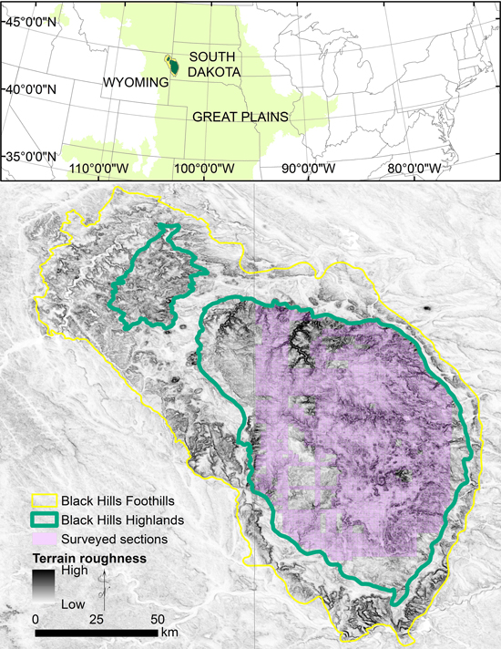
Fig. 1. The Black Hills in South Dakota and Wyoming, USA, is an area of mountainous topography (terrain roughness displays elevation steepness) embedded within the Great Plains grasslands of the central United States. The Black Hills is comprised of the Black Hills Foothills and Highlands ecological subsections. The study extent is the area with available records of tree surveys in South Dakota (purple).
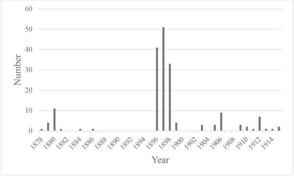
Fig. 2. Number of General Land Office surveys by year in the Black Hills, South Dakota, USA.
| Table 1. Composition and diameter of trees (diameters ≥12.7 cm at 1.37 m height) for historical (years 1878 to 1915) and current (years 2011 to 2016) surveys in the South Dakota Black Hills, USA. | ||||||||
| Species | Historical | Current | ||||||
| Composition | Diameter (cm) | Composition | Diameter (cm) | |||||
| Count | Percent | Mean | Max | Count | Percent | Mean | Max | |
| Pinus ponderosa P. Lawson & C. Lawson (ponderosa pine) | 10 284 | 95.4 | 31.3 | 121.9 | 2950 | 86.2 | 23.9 | 70.1 |
| Picea glauca (Moench) Voss (white spruce) | 157 | 1.5 | 21.8 | 76.2 | 228 | 6.7 | 24.1 | 54.6 |
| Populus tremuloides Michx. (quaking aspen) | 155 | 1.4 | 15.5 | 30.5 | 93 | 2.7 | 19.4 | 36.8 |
| Quercus macrocarpa Michx. (bur oak) | 142 | 1.3 | 26.5 | 91.4 | 71 | 2.1 | 16.2 | 29 |
| Betula papyrifera Marshall (paper birch) | 16 | 0.1 | 14.9 | 20.3 | 29 | 0.8 | 15.9 | 20.8 |
| Juniperus scopulorum Sarg. (Rocky Mountain juniper) | 8 | 0.1 | 22.5 | 30.5 | 22 | 0.6 | 19.6 | 34.3 |
| Ulmus americana L. (American elm) | 7 | 0.1 | 30.5 | 45.7 | 2 | 0.1 | 19.4 | 20.6 |
| Celtis occidentalis L. (hackberry) | 4 | 0 | 15.2 | 15.2 | 1 | 0 | 17 | 17 |
| Acer negundo L. (box elder) | 1 | 0 | 17.8 | 17.8 | 0 | 0 | 0 | 0 |
| Populus deltoides W. Bartram ex Marshall (plains cottonwood) | 1 | 0 | 27.9 | 27.9 | 0 | 0 | 0 | 0 |
| Fraxinus pennsylvanica Marshall (green ash) | 0 | 0 | 0 | 0 | 27 | 0.8 | 17.9 | 37.1 |
| Table 2. Density (trees ha–1; diameters ≥12.7 cm at 1.37 m height) and basal area (BA = basal area in m2 ha–1; diameters ≥12.7 cm) from historical surveys, for survey points with two trees or survey points with three trees (i.e., the fourth tree removed) and unadjusted and adjusted for surveyor bias and density from current surveys in the South Dakota Black Hills, USA. | |||||
| Survey | Density (unadjusted) | Density | Density low | Density high | BA |
| Historical, points with two trees | 84 | 74 | 66 | 82 | 6.9 |
| Historical, points with three trees | 137 | 154 | 146 | 162 | 13.5 |
| Current | 311 | 277 | 345 | 15.4 | |