
Aleksi Knaappila  ,
Henrik Lindberg,
Heidi Tanskanen,
Tuomas Aakala
Ignition probability and fire size in Finnish boreal forests: a nationwide analysis of 10 years of rescue services data
Knaappila A., Lindberg H., Tanskanen H., Aakala T. (2026). Ignition probability and fire size in Finnish boreal forests: a nationwide analysis of 10 years of rescue services data. Silva Fennica vol. 60 no. 3 article id 26006. https://doi.org/10.14214/sf.26006
Highlights
- Relative ignition probability was primarily associated with human population density, day of year, and canopy cover
- Fire size was most strongly influenced by human population density, distance to nearest road, and ignition cause
- Higher human population density increased relative ignition probability but decreased fire size
- Relative ignition probability peaked mid-season, whereas fire size was greatest early in the season.
Abstract
Fires are major disturbances in boreal forests, and forest fire risk is projected to increase in Finland. Despite this, comprehensive large-scale analyses evaluating multiple potential drivers of fire ignition and size remain scarce. The aim of this study was to assess how selected environmental and human-related factors influence the relative ignition probability and fire size in Finnish boreal forests. We utilized data on forest fire occurrence and size, the Finnish Forest Fire Index (FFI), and ignition cause, compiled by rescue authorities across mainland Finland during 2014–2023. We supplemented it with spatial data describing environmental factors (site trafficability, slope, canopy cover, and dominant tree species) and human-related factors (human population density and distance to nearest road). The dataset contained 10 284 forest fire observations and an equal number of pseudo-absence observations. We fitted one generalized additive model (GAM) each to explain relative ignition probability and fire size. The relative ignition probability model explained 51.6% of the deviance and achieved a classification accuracy of 83.7%, while the fire size model explained 21.5% of the deviance. Human-related variables were among the most influential in both models, with human presence increasing relative ignition probability but reducing fire size. Seasonality and weather were also significant, suggesting a major influence of weather and vegetation dynamics on fuel moisture, whereas dominant tree species affected only fire size and slope only relative ignition probability. The contrasting effects of humans on forest fires suggest potential for reducing future fire risk through targeted fire management strategies.
Keywords
Finland;
spatial analysis;
wildfire;
lightning;
fire spread;
human-caused ignitions;
official fire records
-
Knaappila,
University of Eastern Finland, School of Forest Sciences, FI-80101 Joensuu, Finland
 https://orcid.org/0009-0007-7130-1141
E-mail
aleksi.knaappila@uef.fi
-
Lindberg,
Häme University of Applied Sciences, School of Biotechnology and Natural Resources, FI-13100 Hämeenlinna, Finland
https://orcid.org/0000-0001-9045-2673
E-mail
henrik.lindberg@hamk.fi
-
Tanskanen,
Karelia University of Applied Sciences, FI-80200 Joensuu, Finland
https://orcid.org/0009-0008-1619-7000
E-mail
heidi.tanskanen@karelia.fi
-
Aakala,
University of Eastern Finland, School of Forest Sciences, FI-80101 Joensuu, Finland
https://orcid.org/0000-0003-0160-6410
E-mail
tuomas.aakala@uef.fi
Received 21 January 2026 Accepted 16 October 2026 Published 22 October 2026
Views 139
Available at https://doi.org/10.14214/sf.26006 | Download PDF

Supplementary Files
1 Introduction
Fires represent the most significant natural disturbance in boreal forests, shaping composition, structure, and ecological function of forest stands (Zackrisson 1977; Potapov et al. 2008; Molinari et al. 2020). Fires are important for carbon and nutrient cycling (Kasischke et al. 1995; Al-Khayri et al. 2024), as well as biodiversity maintenance (Burton et al. 2008; Ylisirniö et al. 2012; Ramberg et al. 2023), yet they also have negative impacts on human societies, posing threats to safety, livelihoods, and property (Kala 2023) and contributing to degraded air quality (Gorchakov et al. 2017). In addition, carbon emissions from forest fires accelerate climate change (Flannigan et al. 2006; Zheng et al. 2023), which, in recursive manner, is projected to increase both fire occurrence and burnt area (Lehtonen et al. 2016; Venäläinen et al. 2020; Kinnunen et al. 2024).
The occurrence of forest fires (hereafter, fires) in Fennoscandia (i.e., Norway, Sweden, Finland, and parts of northwestern Russia) has varied throughout the Holocene as a result of changing climate, vegetation and human influence (Lynch et al. 2004; Clear et al. 2014; Remy et al. 2023). At present, the vast majority of ignitions are related to human activity (Granström 1993; Larjavaara et al. 2005), with campfires, cigarettes, arsons, and sparks from forestry machinery being the most common causes within this category (Ketola 2018; Sjöström et al. 2019; Sjöström and Granström 2023). Consequently, the number of fires tends to increase with both population density (Cueva et al. 2006; Pinto et al. 2020) and proximity to infrastructure, such as roads (Pew and Larsen 2001; Maingi and Henry 2007). Approximately 10% of the fires are lightning-ignited (Granström 1993; Larjavaara et al. 2005), although area burnt by such fires can occasionally be large (Kelly et al. 2021; Lindberg et al. 2021; Sjöström and Granström 2023), as they also occur in remote and inaccessible rural areas (Ganteaume et al. 2013). Large human-caused fires tend to dominate in spring, between snowmelt and vegetation green-up (Tanskanen and Venäläinen 2008), whereas lightning-ignited fires peak later in the summer (Larjavaara et al. 2005; Venäläinen et al. 2016). These seasonal patterns vary along a latitudinal gradient and are driven by changes in weather, vegetation, and ignition sources (Granström 1993; Larjavaara et al. 2004; Tanskanen 2007).
Majority of fires ignite and spread within surface fuels (Shorohova et al. 2011) that consist of mosses, lichens, herbs, shrubs and litter. Therefore, fire ignition and spread are largely determined by the moisture content of these surface fuels, which in turn is affected by stand characteristics (Tanskanen et al. 2006). Fennoscandian forests are dominated by Scots pine (Pinus sylvestris L.), Norway spruce (Picea abies (L.) H. Karst.), and birches (Betula spp. L.) (Lindbladh et al. 2014; Breidenbach et al. 2021; Korhonen et al. 2024). Xeric, pine-dominated sites are often characterized by open canopy and low surface fuel loads dominated by flammable mosses and lichens (Tanskanen et al. 2006; Lindberg et al. 2024). As a result, low intensity surface fires are common on xeric sites (Päätalo 1998; Wallenius et al. 2002; McRae et al. 2006). In contrast, spruce-dominated stands with closed canopies on mesic sites are typically less flammable (Tanskanen et al. 2006; Brown and Giesecke 2014). Due to higher fuel loads, fires in such forests may result in higher intensity and tree mortality (Wallenius 2002; Ananyev et al. 2022), especially under extreme drought conditions. The abundance of herbs and deciduous trees tends to reduce the flammability on the most fertile sites during the growing season. However, cured grass can dry rapidly, resulting in high flammability in the spring (Lindberg et al. 2011; Parisien et al. 2023).
Topography is a significant driver of fire occurrence, which is observed to be higher on sloping terrain than on flat ground (Engelmark 1987; Holsinger et al. 2016). Slope steepness and aspect influence fuel moisture, as they determine the amount of incoming solar radiation and redistribution of water (Fang et al. 2018). Moreover, slope has a particularly strong effect on fire spread, as heat is transferred efficiently upslope through radiation and convection (Agee 1993; Selvaraj et al. 2024; Shan et al. 2024). Steep slopes can also facilitate the transition of surface fires into crown fires, increasing fire intensity and thus severity (Airey-Lauvaux et al. 2022). Topographic features, such as wet depressions, often act as firebreaks and may remain unburnt for centuries or even millennia (Hörnberg et al. 1995; Hellberg et al. 2004; Wallenius et al. 2005).
Previous studies have identified numerous factors affecting fire ignition and spread. Determining the relative importance of these factors is increasingly critical given the anticipated changes in future fire occurrence. However, comprehensive national-scale analyses evaluating multiple potential drivers simultaneously remain scarce (Pinto et al. 2020; Cimdins et al. 2022; Jones et al. 2025). Using spatially explicit data on ignitions and fire sizes compiled by rescue authorities, the aim of this study was to assess the influence of selected environmental and human-related factors on fire ignition and size. Specifically, we evaluated how (1) soils and topography, (2) stand structure and composition, (3) season and weather, and (4) human-related factors influence relative ignition probability and fire size in boreal forests of Finland.
2 Material and methods
2.1 Study area
The study area covered Finland, excluding the Åland Islands, and is located approximately between the latitudes 60°N and 70°N. The topography of Finland is characterized by gentle elevational variations, with approximately 74% of the terrain lying below 200 meters above sea level (National Land Survey of Finland 2024a). Highest elevations are in the eastern and northern regions of the country.
The vast majority of Finland belongs to the boreal zone (Olson et al. 2001) and is characterized by a subarctic climate, with relatively cold and short summers (Peel et al. 2007). On average, February is the coldest month with a mean temperature of −8.5 °C, whereas the warmest is July with 16 ℃ (Finnish Meteorological Institute 2025). The annual precipitation is approximately 600 mm, with the lowest value occurring in spring (ca. 100 mm) and the highest in summer (ca. 200 mm) (Irannezhad et al. 2014). The fire season starts typically in April and lasts until October (Tanskanen and Venäläinen 2008), varying across the country (Saari 1923; Kinnunen et al. 2024), with the majority of fires occurring between May and August. The beginning of the season is characterized by large human-related fires, whereas most lightning-ignited fires, as well as most cloud-to-ground lightning strikes, occur in July (Larjavaara et al. 2005; Mäkelä et al. 2014; Lehtonen et al. 2016).
Approximately 86% of Finland’s land area is classified as forest, of which 64% grows on mineral soils and 35% on peatlands (Korhonen et al. 2024). The forests are almost entirely dominated by Scots pine (63%), Norway spruce (25%), and birches (9%). In coniferous stands, ground layer is composed mainly of quick-drying species, such as feather moss (Pleurozium schreberi (Willd. ex Brid.) Mitt.), stairstep moss (Hylocomium splendens (Hedw.) Schimp.), fork mosses (Dicranum spp. Hedw.) and reindeer lichens (Cladonia spp. P. Browne) (Schimmel and Granström 1997; Mäkipää et al. 2000; Lindberg et al. 2024). Lichens are generally common on xeric sites, and they are gradually displaced by mosses under more mesic conditions (Cajander 1926; Lindberg et al. 2011). On the most fertile sites, herbs and deciduous trees are abundant.
Finland is the third most sparsely populated country in Europe, with an average of 18.4 persons km−2 (Eurostat 2025), and an unevenly distributed population as the density is the highest in the southwestern parts of the country (Adamiak et al. 2017). The forests are largely under commercial management, with only 6% remaining in a natural or near-natural state, the vast majority of which are located in northern Finland (Korhonen et al. 2024). Consequently, the country has a relatively dense forest road network, which follows a similar regional distribution as managed forests (Uotila and Viitala 2000) and facilitates access to fire sites and effective fire suppression (Päätalo 1998).
In Finland, only a few hundred hectares of forest burn each year, with an average fire size of approximately 0.5 ha (Lindberg et al. 2021). Burnt area has been lower than in neighboring Sweden and Republic of Karelia, largely due to intensive forest management practices combined with extensive fire prevention and suppression efforts (Kosenius et al. 2014; Lindberg et al. 2021), although the underlying explanatory factors may be more nuanced in Sweden.
2.2 Data preparation
2.2.1 Forest fire data
This study was based on wildfire data obtained from Finnish rescue services’ resource and accident statistics system, PRONTO (Emergency Services Academy Finland 2025), covering mainland Finland from 2014 to 2023. PRONTO contains information on incidents and the actions of rescue authorities at the scene (Emergency Services Academy Finland 2013). In this study, we used date, coordinates of the estimated ignition point, terrain type, Finnish Forest Fire Index (FFI), ignition cause, and fire size (Table 1). Spatial data from the statistics system were limited to point locations and did not include information on the shape or orientation of burnt areas. The advantages of PRONTO data included its broad geographical and temporal coverage, as well as the systematic approach of its collection.
| Table 1. Summary of the variables. | |||
| Variable | Description | Type | Source |
| Fire occurrence (response) | Division into observed forest fires and pseudo-absence observations (0 = pseudo-absence, 1 = fire occurrence) | binary | PRONTO1 |
| Fire size (response) | Total burnt area in terrain types considered forest, with a logarithmic transformation (ha) | numerical | PRONTO1 |
| Coordinates | Location of the ignition point | numerical | PRONTO1 |
| Year | Calendar year (2014–2023) | numerical | PRONTO1 |
| Trafficability | Bearing capacity of the terrain (1–6; 1 = the highest, 6 = the lowest) | categorical | Soil trafficability map, Finnish Forest Centre |
| Slope | Terrain slope at the ignition point (°) | numerical | Elevation model 10 m, National Land Survey of Finland |
| Canopy cover | Proportion of ground covered by the vertical projection of tree crowns (%) | numerical | MS-NFI2 |
| Dominant species | Tree species, covering at least 50% of the total growing stock volume (Pine, Spruce, Deciduous, or Mixed) | categorical | MS-NFI2 |
| Day of year | Sequential calendar day number within the year (0–366) | numerical | PRONTO1 |
| Finnish Forest Fire Index (FFI) | Latest index value prior to fire in the municipality, to one decimal precision (1.0–6.0) | numerical | PRONTO1 |
| Ignition cause | Reclassified ignition cause, based on fire authorities' assessment (Human, Lightning, or Unknown) | categorical | PRONTO1 |
| Population density | Interpolated population density as of 31st December of the preceding year (persons km⁻2) | numerical | Population grid data 1 km × 1 km, Statistics Finland |
| Distance to nearest road | Euclidean distance between the ignition point and the nearest road, including classes road, roadway, track, pedestrian and bicycle route, and winter road (km) | numerical | Topographic Database, National Land Survey of Finland |
| 1 Finnish rescue services’ resource and accident statistics system, Emergency Services Academy Finland 2 Multi-Source National Forest Inventory, Natural Resources Institute Finland | |||
While the rescue authorities had recorded other data, the FFI value of the municipality had been obtained from the Finnish Meteorological Institute to the statistics system. The index estimates the moisture content of the surface fuels and is calculated from meteorological observations, including temperature, precipitation, air humidity, wind speed, and solar radiation (Venäläinen and Heikinheimo 2003), ranging from 1.0 to 6.0. FFI was included in the analyses as it integrates weather conditions affecting fuel moisture and fire danger. To analyze fire seasonality, we used day of year. Numerous ignition causes were recorded in the statistics system but were here coarsely reclassified into three categories: human, lightning, and unknown (Supplementary file S1).
From the data, fires started as wildfires in terrain types classified as forest – either closed-canopy forest, forest clearing, or peatland – were treated as forest fires and included in the analyses (Emergency Services Academy Finland 2013). When a fire had occurred in more than one terrain type, fire size was calculated by summing the burnt forest areas in the three forested terrain types. Fires with obvious recording errors, such as unrealistically large increases in fire sizes during suppression operations, invalid FFI values, or duplicate coordinates, were excluded. For example, fires with one or more orders-of-magnitude increases in size between the arrival of the rescue authorities and the end of the incident were omitted, as we considered them unit conversion errors.
The fire data lacked detailed information on environmental conditions at the ignition sites. Therefore, we supplemented it with open spatial data that provided consistent, spatially explicit information on key factors influencing fire ignition and spread. These included variables associated with soils (trafficability), topography (slope), stand structure (canopy cover) and composition (dominant species), and human-related factors (population density, distance to nearest road) at the ignition point of each fire, enabling systematic analyses of their influence on fire ignition and spread (Table 1).
A total of 28 021 wildfires were recorded in PRONTO, including 13 001 forest fires, of which 10 284 were retained for analyses after excluding observations with recording errors or missing values in any of the study variables. Most exclusions were due to missing values in supplementary data. Within the retained dataset, 65.4% of fires were human-caused, while lightning had ignited 15.4% of them (Table 2). The median fire size was 0.008 ha, the mean size was 0.45 ha, and the average annual burnt forest area was 460 ha. Considering all forest fires recorded in PRONTO, fire density appeared to be highest in southern and southwestern Finland, with fires clustered around human settlements (Fig. 1).
| Table 2. Summary statistics of the forest fires included in the analyses. | |||||||
| Year | Number of fires | Ignition cause (%) | Fire size (ha) | ||||
| Human | Lightning | Unknown | Median | Mean | Sum | ||
| 2014 | 1320 | 54.5 | 29.5 | 16.1 | 0.020 | 0.55 | 721 |
| 2015 | 629 | 73.9 | 3.5 | 22.6 | 0.003 | 0.17 | 107 |
| 2016 | 772 | 80.8 | 3.1 | 16.1 | 0.005 | 0.31 | 238 |
| 2017 | 746 | 82.0 | 2.1 | 15.8 | 0.010 | 0.73 | 543 |
| 2018 | 1892 | 55.1 | 19.7 | 25.3 | 0.010 | 0.48 | 910 |
| 2019 | 1071 | 62.9 | 15.1 | 21.9 | 0.005 | 0.28 | 296 |
| 2020 | 1046 | 73.6 | 10.2 | 16.2 | 0.008 | 0.65 | 683 |
| 2021 | 1019 | 58.3 | 21.6 | 20.1 | 0.005 | 0.56 | 575 |
| 2022 | 845 | 72.9 | 13.4 | 13.7 | 0.002 | 0.24 | 199 |
| 2023 | 944 | 64.7 | 16.6 | 18.6 | 0.005 | 0.35 | 330 |
| All | 10 284 | 65.4 | 15.4 | 19.2 | 0.008 | 0.45 | 460 |
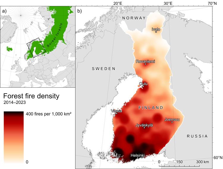
Fig. 1. Maps showing a) the location of the study area within the boreal region (University of Minnesota 2017; The World Bank 2025) and b) the spatial distribution of forest fires recorded in PRONTO, visualized as a kernel density heatmap.
2.2.2 Soils and topography
To analyze the influence of soils, particularly the variation along the moisture gradient, we used soil trafficability data (Finnish Forest Centre 2025). The trafficability was based on a combination of topographic wetness index, elevation, soil type, growing stock volume and site drainage, reflecting the bearing capacity of the terrain (Kilpiäinen 2022). The data consisted of six categories, with class 1 indicating the highest capacity and class 6 the lowest. Classes 1–3 represented mineral soils, whereas classes 4–6 represented peatlands. As trafficability was a categorical variable, the most frequently occurring value within a 25-meter buffer was extracted for each fire observation. The buffer size was chosen to represent the immediate surroundings of the ignition point and to provide a compromise between spatial precision and robustness. Similar fixed-radius buffers have also been applied in previous fire studies (Pinto et al. 2020). At the time of this study, the trafficability data were a relatively new product and therefore did not yet provide full coverage of Finland.
Terrain slope was included as a key topographic factor, as it influences ignition probability via fuel moisture and directly affects fire spread. Slope was calculated from the Elevation model 10 m (National Land Survey of Finland 2024a) using the Slope tool in ArcGIS Pro (version 3.5.4, Esri 2026). Slope values were extracted directly from the raster cells in which the ignition points were located.
2.2.3 Stand structure and composition
Canopy cover and dominant tree species were included as stand characteristics influencing fundamental fuel properties (Table 1). They were derived from the Multi-Source National Forest Inventory (MS-NFI) data (Natural Resources Institute Finland 2024) which had a temporal resolution of two years. The values were obtained from the most recent data available prior to each fire. According to Mäkisara et al. (2022) the estimation RMSE errors are substantial at the scale of individual cells: for species-specific volumes ranging from 6 to 67 m3 ha–1 and canopy cover around 16%, depending on region and soil type. However, the errors diminish when the analyzed area contains multiple 16 meter by 16 meter cells (Natural Resources Institute Finland 2023). Therefore, we calculated the values for the continuous numerical variables as mean values within a 25-meter radius.
The dominant species was derived from growing stock volumes of Scots pine, Norway spruce, birch, and other deciduous trees. The possible categories were pine, spruce and deciduous, if the relative volume of such species exceeded 50%, and mixed in situations where the above condition was not met. The canopy cover was fixed to 0% if the main terrain type defined by the rescue authorities was a forest clearing. This was justified, as the most recent clear-cuts – which are prone to fire (Tanskanen et al. 2005; Lindenmayer et al. 2009; Chen et al. 2015) – were not captured in the MS-NFI data due to its temporal resolution.
2.2.4 Human-related factors
Human population density was included to represent human presence affecting both ignition probability and fire spread (Table 1). Population grid data 1 km × 1 km (Statistics Finland 2024) expressed the population density in persons km−2 and had a temporal resolution of one year. The data were interpolated to produce smooth raster surfaces, improving the representation of human influence at the ignition points compared to sharply contrasted population counts in discrete grid cells. The interpolation was performed using the inverse distance weighted (IDW) method in QGIS (version 4.0.0, QGIS Development Team 2026). In the interpolation process, we utilized both the populated and unpopulated centroids, set the distance coefficient to 1, and finally extracted the values directly from the cells ignition points located using the most recent data available prior to each fire.
Distance to nearest road was included as an indicator of accessibility, influencing both human-caused ignitions and access for fire suppression. It was calculated as Euclidean distance between the ignition point and the nearest road from the Topographic Database (National Land Survey of Finland 2024b). Classes road, roadway, track, pedestrian and bicycle route, and winter road from the most recent database were used in this study.
2.3 Statistical analyses
We used generalized additive models (GAMs) as non-linear relationships between some variables were observed during exploratory analyses. Two models were fitted with the functions of the mgcv package (Wood 2011) in R (version 4.5.3, R Core Team 2026): one for relative ignition probability, and the other for fire size (Suppl. file S2). Spline functions were applied as smoothers for the continuous variables. A double penalty approach (Marra and Wood 2011) was used for model selection, and the conventional significance level of α = 0.05 was applied in the analyses. Collinearity between variables was assessed using Pearson correlation coefficient, and one variable from each pair with |r| > 0.25 was excluded from the GAM models. Concurvity among the smooth terms was evaluated (Wood 2011), and either term was excluded if the concurvity value exceeded 0.5 (Kovács 2024).
To model relative ignition probability, we first fitted a GAM using a binary response variable indicating the presence or absence of a fire observation. Because the data contained only observed fires, we generated pseudo-absence data by randomly sampling points across mainland Finland from 2014 to 2023. These points represented non-fire observations, enabling the binary response variable to be coded as 1 for fires and 0for pseudo-absences, with predictor variables obtained in the same manner as for the fire observations. Consequently, the estimated relative ignition probability refers to the probability of an observation being a fire rather than a pseudo-absence, not to the absolute probability of ignition. Similar approach based on pseudo-absence data has been applied in previous fire studies (Pinto et al. 2020).
We applied a binomial error distribution with logit link function and randomly limited the pseudo-absence dataset to match the number of observed fires (n = 10 284), under the assumption that the pseudo-absence observations represented the environmental background of the study area. The explanatory variables in the model included trafficability, slope, canopy cover, dominant species, day of year, population density, and distance to nearest road. We modelled slope using a low-complexity smooth term (k = 3) and distance to nearest road as a linear term, because more flexible smoothers produced unrealistically wavelike patterns. The classification accuracy of the binomial model was calculated to evaluate its ability to correctly distinguish observed fires from pseudo-absence observations, using a 50% probability threshold.
Subsequently, we fitted another GAM with fire size as the response variable, applying a logarithmic transformation because its distribution was heavily right-skewed. The explanatory variables included the same predictors as in the first model, with the addition of the FFI and ignition cause. We modeled variables slope and distance to nearest road without a smoother, because more flexible smoothers produced unrealistically wavelike patterns. A Gaussian error distribution with an identity link function was applied.
Spatial autocorrelation of the model residuals was assessed using Moran’s I (Bivand and Wong 2018). We observed weak, but statistically significant autocorrelation, which rapidly declined with increasing distance. As a sensitivity analysis, additional models including a two-dimensional smooth of spatial coordinates, s(easting, northing), were fitted for both response variables. The spatial term reduced the magnitude of autocorrelation, but the distance-dependent pattern remained largely unchanged (Suppl. file S3). The coordinates were strongly associated with population density and distance to nearest road, and inclusion of the spatial term reduced the effect sizes of these human-related variables, suggesting potential spatial confounding between the terms. However, inclusion of the spatial term neither altered the main conclusions nor fully removed the residual spatial autocorrelation. We therefore report the non-spatial models as the primary models.
3 Results
3.1 Relative ignition probability model
Relative ignition probability was explained by population density, day of year, canopy cover, trafficability, distance to nearest road and slope (in descending order of χ2-statistic; all with p < 0.001; Table 3). Dominant species was not statistically significant (p = 0.918). Overall, the model explained 51.6% of the deviance and correctly predicted 83.7% of the observed response values using a 50% probability threshold.
| Table 3. Terms in the relative ignition probability model, listed in descending order of χ2-statistic. The s() denotes a spline function applied to the variable. | ||
| Term | χ2-value | p-value |
| s(population density) | 1567.8 | <0.001 |
| s(day of year) | 1565.6 | <0.001 |
| s(canopy cover) | 679.3 | <0.001 |
| trafficability | 317.9 | <0.001 |
| distance to nearest road | 147.0 | <0.001 |
| s(slope) | 126.3 | <0.001 |
| dominant species | 0.5 | 0.918 |
On average, the ignition probability decreased with reduced trafficability (Fig. 2a). The most pronounced differences were observed between mineral and peat soil classes, with the highest probability on mineral soils and almost non-overlapping confidence intervals between the two soil types. The widest confidence intervals and fewest observations were associated with peat classes 4 and 5, which represent intermediate to low bearing capacity on the six-class scale. The relationship between ignition probability and slope was positive and largely monotonic, while the confidence interval remained constant across the observed range of slope values (Fig. 2b).
The ignition probability was highest at 0% canopy cover and decreased sharply up to approximately 15% canopy cover (Fig. 2c). It then increased slightly and remained relatively stable between 20% and 70% canopy cover, after which it declined sharply again. We observed the lowest probabilities around 15% and above 80% canopy cover. The probability did not differ among the dominant species (Fig. 2d).
Among the terms in the model, the association between ignition probability and day of year was particularly strong, with probability varying substantially over the course of the year (Fig. 2e). Starting in early March, ignition probability increased rapidly until late May, with a gradual increase until peaking in July, followed by a sharp decline. By November, it had dropped near zero, where it remained throughout the winter months. The seasonal pattern of the FFI closely resembled that of ignition probability.
Population density was also an important predictor, as ignition probability increased markedly with increasing population density (Fig. 2f). The confidence interval widened considerably at higher population densities, where the number of observations declined sharply and became sparse along the gradient. We modelled distance to nearest road as a linear term; on the response scale, ignition probability decreased strongly and monotonically with increasing distance from roads (Fig. 2g).
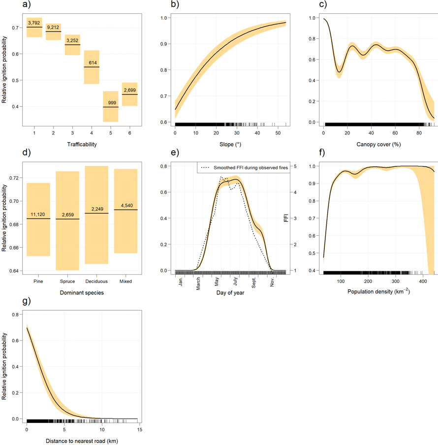
Fig. 2. Response of relative ignition probability to a) trafficability, b) slope, c) canopy cover, d) dominant species, e) day of year, f) population density, and g) distance to nearest road. Lines represent the estimated effects and shaded areas 95% confidence intervals. In panel e), the dashed smooth shows variation in the Finnish Forest Fire Index as a function of day of year based on the observed fires. For continuous variables, tick marks indicate observation density; for categorical variables, class frequencies are shown.
3.2 Fire size model
Predictors explaining fire size were population density, distance to nearest road, ignition cause, day of year, the Finnish Forest Fire Index (FFI), trafficability, canopy cover and dominant species (in descending order of F-statistic; all with p < 0.001; Table 4). Slope was not statistically significant (p = 0.309). Overall, the model explained 21.5% of the deviance.
| Table 4. Terms in the fire size model, listed in descending order of F-statistic. The s() denotes a spline function applied to the variable. | ||
| Term | F-value | p-value |
| s(population density) | 121.7 | <0.001 |
| distance to nearest road | 76.7 | <0.001 |
| ignition cause | 76.0 | <0.001 |
| s(day of year) | 48.2 | <0.001 |
| s(Finnish Forest Fire Index) | 22.7 | <0.001 |
| trafficability | 8.5 | <0.001 |
| s(canopy cover) | 6.8 | <0.001 |
| dominant species | 6.6 | <0.001 |
| slope | 1.0 | 0.309 |
In mineral soil classes, fire size decreased as trafficability declined, whereas peat soil classes did not follow this trend (Fig. 3a). On peatlands, fire size was considerably more variable, and their confidence intervals showed notable overlap. Fire size increased very slightly with slope, but the wide confidence interval and lack of statistical significance provided no support for a consistent relationship (Fig. 3b).
As canopy cover increased, fire size decreased relatively steadily, although the spline indicated slight nonlinearity in the relationship (Fig. 3c). Fires were largest in deciduous stands, followed by pine-dominated stands, and smallest in spruce-dominated stands (Fig. 3d). In mixed stands, the fire size was intermediate between that of pine- and spruce-dominated stands. However, the confidence intervals overlapped, suggesting that differences among dominant species were minor.
The fire size indicated an overall decreasing trend as the year progressed, although we observed considerable variation at the beginning of the fire season (Fig. 3e). Fires were largest in spring, followed by a decline in size until leveling off during summer months. From September onwards, fire size remained consistently low. In addition to seasonal variation, the fire size increased steadily as the FFI rose, but this trend plateaued at index values above 4.0 (Fig. 3f).
The size of human-caused fires was remarkably smaller than that of fires ignited by lightning (Fig. 3g). The size of lightning-ignited fires was comparable to that of fires with an unknown cause. The confidence intervals for human- and lightning-ignited fires did not overlap at all, indicating a significant difference. Analogously, the fire size decreased rapidly with increasing population density (Fig. 3h). We modelled distance to nearest road as a linear term; on the response scale, a clear positive relationship was observed, although the confidence interval widened at greater distances, likely due to a lower number of observations (Fig. 3i).
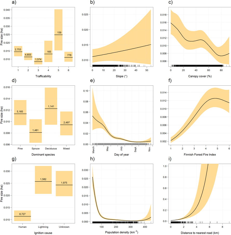
Fig. 3. Response of fire size to a) trafficability, b) slope, c) canopy cover, d) dominant species, e) day of year, f) the Finnish Forest Fire Index, g) ignition cause, h) population density, and i) distance to nearest road. Lines represent the estimated effects and shaded areas 95% confidence intervals. For continuous variables, tick marks indicate observation density; for categorical variables, class frequencies are shown.
4 Discussion
4.1 Drivers of relative ignition probability and fire size
In this study, we analyzed 10 284 forest fire observations from 2014 to 2023 using two GAMs to assess the influence of selected environmental and human-related factors on relative ignition probability and fire size in the boreal forests of Finland. Here, relative ignition probability refers to the probability of a fire observation relative to a pseudo-absence observation. The probability model performed well, explaining 51.6% of the deviance and demonstrating strong discriminative capacity between fire observations and control locations. The fire size model performed moderately, explaining 21.5% of the deviance. Difference in model performance likely reflects the nature of underlying phenomena: an ignition occurs at a specific point, while fire spread is dependent on possibly heterogeneous conditions surrounding the ignition point. In addition, efficient fire detection and suppression substantially limits fire spread in Finland (Lindberg et al. 2021) and may therefore weaken the relationship between fire size and environmental variables. Consequently, the explanatory variables may have captured ignition conditions more effectively than those controlling fire spread.
Ignition probability was primarily associated with population density, day of year, and canopy cover, while dominant species had no effect on the probability. Canopy cover showed a nonlinear relationship, with highest probability at 0% cover and lowest around 15% and above 80%. As documented before in nearby Sweden (Sjöström and Granström 2023), fire size was strongly associated with human-related factors, including population density, distance to nearest road, and ignition cause, whereas slope showed no significant effect. Human-caused fires tended to be substantially smaller than fires ignited by lightning, consistent with previous studies (Sjöström and Granström 2023). In both models, population density was among the strongest predictors, positively affecting the ignition probability and negatively the fire size. Seasonal variation was also evident, with the probability peaking in the middle of the fire season and fire size being largest at the beginning.
4.1.1 Soils and topography
The ignition probability decreased as trafficability declined. Since the trafficability is associated with soil moisture (calculated from topographic wetness index, soil type and site drainage; Kilpiäinen 2022), the results are in line with previous studies showing that fire frequency decreases with increasing soil moisture (Saari 1923; Bartsch et al. 2009; Aakala et al. 2018; Jones et al. 2025) and higher fire occurrence of xeric sites compared to mesic sites (Päätalo 1998; Wallenius et al. 2002, 2004). On mineral soils, fire size clearly decreased as the trafficability declined, but peatlands showed higher variation. The confidence intervals for fire size on peatlands were remarkably large, which may be result of the low number of observations on peatlands. This may also reflect the specific characteristics of peatland fires: due to high moisture, they normally burn poorly but under exceptionally dry conditions, fire spreads also into the peat layer (Ryan 2002). In such cases, fires can smolder over extensive areas due to continuous fuel availability and difficulties in detection and control (Lindberg et al. 2011; Scholten et al. 2021; Qin et al. 2025).
Slope has been observed to be a significant determinant of fire ignition (Cimdins et al. 2022), a finding supported by this study. This may be due to increased solar radiation reaching the forest floor and enhanced water runoff with increasing slope steepness, leading to lower soil moisture (Rollins et al. 2002; Fang et al. 2018; Guo et al. 2020). The effect of the slope was not as clearly visible in the model explaining the fire size; instead, the rapid fire spread caused by slope, as reported in previous experimental studies (Perry 1987; Agee 1993; Shan et al. 2024; Selvaraj et al. 2024) was not identified here. Most likely, the topography of Finland does not provide sufficient variation in slope steepness (Tanskanen 2007; National Land Survey of Finland 2024a) to capture the phenomenon, indicating a smaller role of topographical variation in Finnish forests, compared to many other countries.
4.1.2 Stand structure and composition
Ignition probability decreased nonlinearly with increasing canopy cover. The probability was highest in clear-cut areas, likely driven by increased solar radiation and wind exposure reducing surface fuel moisture (Tanskanen et al. 2005; Lindenmayer et al. 2009; Chen et al. 2015), particularly when post-harvest water table rise does not offset surface fuel drying (Korrensalo et al. 2026). The initially high ignition probability decreased steeply when canopy cover increased from 0to 15%. This decline may be explained by the rapid growth of herbs and deciduous trees, decomposition of postharvest fine fuels, as well as the absence of mosses, following harvest (Schimmel and Granström 1997; Pykälä 2004; Nesbit et al. 2023). After this, the displacement of low-flammability vegetation both naturally (Pykälä 2004) and as a result of forest management (Äijälä et al. 2019), may cause the later increase in ignition probability. In this process, fuels with low flammability are replaced by more flammable moss and lichen species and coniferous trees (Schimmel and Granström 1997; Lindberg et al. 2024). With higher canopy cover, the decrease in probability is likely due to microclimate becoming more humid and less windy (Tanskanen et al. 2005) as well as the reduced growth of understory (Jonsson Čabrajič et al. 2010). The somewhat linear decrease in fire size with increasing canopy cover is also likely a result of the same phenomenon. Given that Finnish forests are extensively managed (Korhonen et al. 2024) and that soil scarification on clear-cuts contributes to numerous ignitions and a substantial proportion of the burnt area (Sjöström et al. 2019), the high ignition probability and fire size observed in clear-cuts can be interpreted as an indirect human influence.
Fires were large in pine-dominated stands, likely due to pine dominating stands on permeable soils (Cajander 1926; Mäkitalo 2009), where large surface fires have historically been frequent (Saari 1923; Wallenius et al. 2002; McRae et al. 2006). In contrast, fire size was lower in spruce-dominated stands, as spruce typically occurs on more mesic sites and creates less favorable microclimatic conditions for fire spread (Saari 1923; Wallenius et al. 2004; Ohlson et al. 2011; Brown and Giesecke 2014). In mixed stands, fire size fell between those observed in monospecific stands, as if representing an average (Plathner et al. 2022). However, this study showed no evidence for differences in ignition probability among the dominant tree species. This suggests that tree species composition may be more important for fire behavior than for the initial ignition.
Deciduous stands are typically less susceptible to fire, as litter from broadleaves are less flammable than needles (Blauw et al. 2017; Plathner et al. 2022; Nesbit et al. 2023; Jones et al. 2025), and the understory typically consists of low-flammability herbs, lacking mosses and lichens (Lindberg et al. 2011; Salemaa et al. 2023). Therefore, it was somewhat unexpected that fires tended to be largest in deciduous stands. This observation may result from the occurrence of larger fires in spring, prior to vegetation green-up (Tanskanen and Venäläinen 2008; Drobyshev et al. 2012; Donis et al. 2017), when the proportion of dead herbs is highest (Nesbit et al. 2023; Parisien et al. 2023), and a leafless canopy allows cured grass to dry out rapidly (Hély et al. 2000). This interpretation was further supported by the earlier occurrence of fires in deciduous stands compared to pine- and spruce-dominated stands. However, the difference in fire size between the pine-dominated and deciduous stands was not statistically significant: in both stands the median fire size was 0.01 ha, while the mean sizes were 0.60 ha and 0.29 ha, respectively. Therefore, the observed pattern should be interpreted with caution.
4.1.3 Season and weather
Fire size decreased sharply at the beginning of growing season, likely due to influences related to weather and vegetation, integrated into the explanatory variable day of year. In the fire size model, the Finnish Forest Fire Index (FFI) was also included to represent meteorological conditions, such as temperature, precipitation, humidity, wind speed, and solar radiation (Venäläinen and Heikinheimo 2003). Therefore, the decline in fire size from March to June suggests that seasonal vegetation dynamics, rather than weather, were the primary drivers. The decline coincides with the green-up, during which the proportion of living herbs – and consequently fuel moisture content – increases rapidly (Nesbit et al. 2023; Parisien et al. 2023). As the growing season progressed, fire size continued to decrease gradually, likely due to the ongoing accumulation of living fuel (Hély et al. 2000).
The ignition probability was highest from May to July, consistent with previous observations in Finland (Larjavaara et al. 2004; Tanskanen 2007; Tanskanen and Venäläinen 2008) as well as in neighboring Sweden and Latvia (Drobyshev et al. 2012; Donis et al. 2017). Since the day of year spline did not decrease during the green-up, and no weather observations were included in the model, the response is likely driven primarily by weather conditions (Venäläinen and Heikinheimo 2003). This is supported by the similarity between the smooths of day of year explaining FFI and ignition probability, both of which show nearly identical seasonal trends (Fig. 2e). Hence, the sharp increase in the ignition probability during spring likely resulted from rising temperatures, snowmelt and low precipitation. Similarly, declining temperatures, increasing air humidity, and persistently high precipitation reduced the flammability from August onwards (Finnish Meteorological Institute 2025). However, because the effects of weather and vegetation cannot be separated in the variable, the stabilization of ignition probability in June may be associated with the accumulation of live vegetation. In addition, human fire activity tends to peak simultaneously with high forest flammability at the start of the fire season and during the summer vacation period, declining towards the end of summer (Tanskanen and Venäläinen 2008).
4.1.4 Human-related factors
Population density was among the most influential variables in both models: ignition probability increased, and fire size decreased, with increasing population density. Previous studies have identified population density as a key factor influencing both the fire occurrence and size (Pinto et al. 2020; Cimdins et al. 2022), since majority of fires are human-caused (Larjavaara et al. 2005; Ketola 2018), and effective fire suppression plays a major role in controlling fire spread (Lindberg et al. 2021).
The effect of ignition cause on fire size further supported the strong role of human influence: fires caused by human tended to be considerably smaller than those ignited by lightning. This is most likely due to human presence near the ignition site, enabling faster and more effective fire detection and suppression. In contrast, lightning-ignited fires are more likely to go unnoticed during their initial stages, allowing the fire to spread over a larger area (Ganteaume et al. 2013). Fires with an unknown ignition source were almost as large as lightning-ignited fires, suggesting that a substantial part of the unknown fires were, in fact, lightning-ignited. This is reasonable, as such fires also occur in remote areas (Ganteaume et al. 2013), making the ignition cause identification more challenging.
While ignition probability decreased with increasing distance from roads, fire size increased. This result is consistent with previous studies reporting a greater occurrence of fires near infrastructure due to human-caused ignitions (Pew and Larsen 2001; Maingi and Henry 2007). Roads increase forest accessibility and the number of potential ignition locations (Lindenmayer et al. 2009). In contrast, fire size correlated positively with the distance, as a denser forest road network facilitates fire suppression and creates firebreaks (Päätalo 1998; Lindberg et al. 2021).
4.2 Limitations
Human influence on both relative ignition probability and fire size was evident. However, the effects of human-related factors were partly confounded by their strong association with geographic coordinates. Inclusion of a spatial term absorbed part of the variation attributed to population density and distance to nearest road, complicating the separation of their effects. Nevertheless, the observed relationships and overall conclusions remained unchanged. Because the spatial models did not fully remove the residual spatial autocorrelation, we reported the primary models without the spatial term.
The variables derived from the PRONTO data are considered reliable as they are based on automatically recorded information (time, FFI) and observations recorded on-site by the rescue authorities (coordinates, terrain type, ignition cause, fire size). Among these PRONTO variables utilized, the greatest uncertainty was associated with the estimation of fire size and ignition cause. In Sweden, the area estimations have been found to be unreliable, mostly overestimations, as the rescue authorities are not normally trained for this task, and the same issue also appears in Finland (Lindberg et al. 2021). Ignition causes were not based on official fire cause investigations (Emergency Services Academy Finland 2013); however, the coarse reclassification of ignition causes mitigated this effect.
The positional accuracy of the PRONTO data was not further assessed. Such uncertainty may affect the extraction of spatial predictor variables, particularly for variables without a smooth spatial gradient, such as stand characteristics. Here, we reduced potential positional errors for selected predictors by applying buffers with a radius of 25 meters around ignition points.
The reliability of the variables derived from open spatial data varied considerably. The most reliable variables were likely slope, population density and distance to nearest road, as they rely on well-defined datasets. In contrast, the variables describing the stand characteristics and soil are largely based on remote sensing and model-based estimations (Mäkisara et al. 2022); in addition, information on trafficability has not been field-verified, which introduces uncertainty and potential errors (Finnish Forest Centre 2025). However, assuming that the estimates were unbiased, the result was increased noise, which was partly mitigated by the large size of the dataset and the coarse resolution of categorical variables (dominant species). For example, moderate errors in growing stock volume did not significantly affect the determination of the dominant species when using four classes and a 50% threshold.
Temporal mismatches between the fire observations and MS-NFI data may introduce some uncertainty, which is expected to be minor at the spatial scale of the analyses. The most probable source of error are human-caused forest structure changes, as timescale of natural dynamics is relatively longer. Nevertheless, MS-NFI data provided the best temporal consistency and the most comprehensive geographical coverage, although higher-resolution datasets, such as laser scanning–based products, exist (Mäkisara et al. 2022).
We derived variables representing stand characteristics within a 25-meter radius around the ignition point, corresponding to approximately 0.2 ha (smaller than the mean fire size of 0.45 ha). Consequently, stand characteristics at larger spatial scales remained unknown in this study, allowing for the possibility that ignition could have occurred, for example, on an upland patch surrounded by waterlogged soils where fire spread is limited. This suggests that the model explaining fire size likely omitted certain influencing factors. However, the use of a fixed radius represents a compromise between spatial precision and robustness.
As fire observations were clustered near human settlements, randomly sampled pseudo-absence data may have affected the estimated importance of human-related variables in the relative ignition probability model. Similar issues have been recognized in ecological research based on voluntary observations, often characterized by spatially uneven sampling effort (Dickinson et al. 2010). It is possible that small fires ignited in remote areas have gone unnoticed; however, as significant authoritative resources are dedicated to fire detection and suppression in Finland, we assumed that the PRONTO data provided broad coverage of fires and were not spatially biased. In addition, the large random sample provided a baseline representation of national conditions, allowing comparison with the presence data. Alternative sampling methods could still provide additional insights in future research.
Ultimately, PRONTO data are not originally intended for forest research purposes. A more detailed description of the data recording protocol would facilitate the use of the data in research. Given that most fires ignite and spread within surface fuels, the lack of extensive data describing these components under varying conditions also represents a significant limitation in fire research. Therefore, improving fire reporting by routinely documenting detailed information on topography, forest structure, and site conditions through inter-agency collaboration is recommended in order to provide more precise data for future research.
5 Conclusions
In this study, we used modern and spatially explicit fire data – compiled by the rescue authorities and newly applied for this purpose – to evaluate how selected environmental and human-related factors are associated with relative ignition probability and fire size in Finnish boreal forests. Although nearly all variables studied were statistically significant, two groups of drivers were prominent: human-related factors and seasonality. The results provide a consistent picture of human influence on ignition and fire spread. Areas accessible to people tend to ignite more frequently, while human presence also enables early fire detection and suppression, limiting fire size. High ignition probability and large fires in clear-cut areas can similarly be considered an indirect human influence. In addition, we demonstrated substantial seasonal variation in fires, likely reflecting weather and vegetation dynamics determining fuel moisture development throughout the year. Together, these findings suggest considerable potential for developing fire management strategies that focus on preventing human-caused ignitions, maintaining effective fire suppression, and considering the effects of forest management on fuel flammability.
Acknowledgements
We acknowledge the Finnish rescue authorities for collecting the wildfire data, and the Emergency Services Academy Finland for providing it for our use. The research was supported by the UNITE flagship funded by the Research Council of Finland (decision number 359172).
Declaration of openness of research materials, data, and code
The wildfire data are confidential and contain sensitive information; access to the data is restricted and managed by the Emergency Services Academy Finland (https://ror.org/02d8tke50). The supplementary predictors were derived from open spatial data produced by the National Land Survey of Finland (https://ror.org/05tkycb73), the Finnish Forest Centre, the Natural Resources Institute Finland (https://ror.org/02hb7bm88), and Statistics Finland (https://ror.org/01n1rg855). Reclassification table for ignition causes, R script, spatial sensitivity analyses and metadata describing the research data are provided as supplementary files of this article.
Authors contribution
Conceptualization: Knaappila A, Aakala T
Data curation: Knaappila A
Formal analysis: Knaappila A
Methodology: Knaappila A, Aakala T
Supervision: Lindberg H, Tanskanen H, Aakala T
Visualization: Knaappila A
Writing – original draft: Knaappila A
Writing – review & editing: Knaappila A, Lindberg H, Tanskanen H, Aakala T
References
Aakala T, Pasanen L, Helama S, Vakkari V, Drobyshev I, Seppä H, Kuuluvainen T, Stivrins N, Wallenius T, Vasander H, Holmström L (2018) Multiscale variation in drought controlled historical forest fire activity in the boreal forests of eastern Fennoscandia. Ecol Monogr 88: 74–91. https://doi.org/10.1002/ecm.1276.
Adamiak C, Pitkänen K, Lehtonen O (2017) Seasonal residence and counterurbanization: the role of second homes in population redistribution in Finland. Geo J 82: 1035–1050. https://doi.org/10.1007/s10708-016-9727-x.
Agee JK (1993) Fire ecology of Pacific Northwest forests. Washington DC. ISBN 1-55963-229-1.
Äijälä O, Koistinen A, Sved J, Vanhatalo K, Väisänen P (eds) (2019) Metsänhoidon suositukset. [Best practices for sustainable forest management in Finland]. Tapion julkaisuja.
Airey-Lauvaux C, Pierce AD, Skinner CN, Taylor AH (2022) Changes in fire behavior caused by fire exclusion and fuel build-up vary with topography in California montane forests, USA. J Environ Manag 304, article id 114255. https://doi.org/10.1016/j.jenvman.2021.114255.
Al-Khayri JM, Khan T, Ahmad M, Shehata WF (2024) Ecological impact of forest fires on soil microbial communities and nutrient cycling in temperate and boreal forests. Sylwan 168: 916–926. https://doi.org/10.26202/SYLWAN.2024058.
Ananyev VA, Timofeeva VV, Kryshen’ AM, Pekkoev AN, Kostina EE, Ruokolainen AV, Moshnikov SA, Medvedeva MV, Polevoi AV, Humala AE (2022) Fire severity controls successional pathways in a fire-affected spruce forest in eastern Fennoscandia. Forests 13, article id 1775. https://doi.org/10.3390/f13111775.
Bartsch A, Balzter H, George C (2009) The influence of regional surface soil moisture anomalies on forest fires in Siberia observed from satellites. Environ Res Lett 4, article id 045021. https://doi.org/10.1088/1748-9326/4/4/045021.
Blauw LG, van Logtestijn RSP, Broekman R, Aerts R, Cornelissen JHC (2017) Tree species identity in high-latitude forests determines fire spread through fuel ladders from branches to soil and vice versa. For Ecol Manag 400: 475–484. https://doi.org/10.1016/j.foreco.2017.06.023.
Breidenbach J, Waser LT, Debella-Gilo M, Schumacher J, Rahlf J, Hauglin M, Puliti S, Astrup R (2021) National mapping and estimation of forest area by dominant tree species using Sentinel-2 data. Can J For Res 51: 365–379. https://doi.org/10.1139/cjfr-2020-0170.
Brown KJ, Giesecke T (2014) Holocene fire disturbance in the boreal forest of central Sweden. Boreas 43: 639–651. https://doi.org/10.1111/bor.12056.
Burton PJ, Parisien M-A, Hicke JA, Hall RJ, Freeburn JT (2008) Large fires as agents of ecological diversity in the North American boreal forest. Int J Wildland Fire 17, article id 754. https://doi.org/10.1071/wf07149.
Cajander AK (1926) The theory of forest types. Acta For Fenn 29. https://doi.org/10.14214/aff.7193.
Chen H, Hu Y, Chang Y, Bu R, Li Y, Liu M (2015) Changes of forest fire regime and landscape pattern under different harvesting modes in a boreal forest of Northeast China. J Arid Land 7: 841–851. https://doi.org/10.1007/s40333-015-0015-2.
Cimdins R, Krasovskiy A, Kraxner F (2022) Regional variability and driving forces behind forest fires in Sweden. Remote Sens 14, article id 5826. https://doi.org/10.3390/rs14225826.
Clear JL, Molinari C, Bradshaw RHW (2014) Holocene fire in Fennoscandia and Denmark. Int J Wildland Fire 23, article id 781. https://doi.org/10.1071/WF13188.
Cueva AV de la, Barrio JMG del, Quero MO, Palomares OS (2006) Recent fire regime in peninsular Spain in relation to forest potential productivity and population density. Int J Wildland Fire 15, article id 397. https://doi.org/10.1071/WF05071.
Dickinson JL, Zuckerberg B, Bonter DN (2010) Citizen science as an ecological research tool: challenges and benefits. Annu Rev Ecol Evol Syst 41: 149–172. https://doi.org/10.1146/annurev-ecolsys-102209-144636.
Donis J, Kitenberga M, Snepsts G, Matisons R, Zarins J, Jansons A (2017) The forest fire regime in Latvia during 1922–2014. Silva Fenn 51, article id 7746. https://doi.org/10.14214/sf.7746.
Drobyshev I, Niklasson M, Linderholm HW (2012) Forest fire activity in Sweden: climatic controls and geographical patterns in 20th century. Agric For Meteorol 154–155: 174–186. https://doi.org/10.1016/j.agrformet.2011.11.002.
Emergency Services Academy Finland (2013) PRONTO – Dynaaminen koulutuskansio – MAASTOPALO. [PRONTO – Dynamic Training Folder – WILDFIRE]. https://www.pelastusopisto.fi/wp-content/uploads/2017/02/46319_e_maastopalo.pdf. Accessed 16 October 2026.
Emergency Services Academy Finland (2025) Statistics (Pronto). https://www.pelastusopisto.fi/en/library-and-information-services/statistics-pronto/. Accessed 16 October 2026.
Engelmark OLA (1987) Fire history correlations to forest type and topography in northern Sweden. Ann Bot Fenn 24: 317–324. https://www.jstor.org/stable/23725752.
Esri (2026) ArcGIS Pro [Computer software].
Eurostat (2025) Population density by NUTS 3 region. https://ec.europa.eu/eurostat/databrowser/view/DEMO_R_D3DENS__custom_672158/bookmark/table?lang=en&bookmarkId=48e7b1e4-7d8d-45db-8717-b7bfd36182a0. Accessed 16 October 2026.
Fang L, Yang J, White M, Liu Z (2018) Predicting potential fire severity using vegetation, topography and surface moisture availability in a Eurasian boreal forest landscape. Forests 9, article id 130. https://doi.org/10.3390/f9030130.
Finnish Forest Centre (2025) Soil trafficability [Geospatial dataset]. https://www.metsakeskus.fi/sites/default/files/document/tietotuotekuvaus-korjuukelpoisuus.pdf. Accessed 17 October 2026.
Finnish Meteorological Institute (2025) Kuukausitilastot. [Monthly statistics]. https://www.ilmatieteenlaitos.fi/kuukausitilastot. Accessed 17 October 2026.
Flannigan MD, Amiro BD, Logan KA, Stocks BJ, Wotton BM (2006) Forest fires and climate change in the 21st century. In: Dixon RK (ed) Mitigation and adaptation strategies for global change 18: 847–859. https://doi.org/10.1007/s11027-005-9020-7.
Ganteaume A, Camia A, Jappiot M, San-Miguel-Ayanz J, Long-Fournel M, Lampin C (2013) A review of the main driving factors of forest fire ignition over Europe. Environ Manag 51: 651–662. https://doi.org/10.1007/s00267-012-9961-z.
Gorchakov GI, Karpov AV, Pankratova NV, Semoutnikova EG, Vasiliev AV, Gorchakova IA (2017) Brown carbon and black carbon in the smoky atmosphere during boreal forest fires. Izv Atmos Ocean Phys 53: 875–884. https://doi.org/10.1134/S0001433817090134.
Granström A (1993) Spatial and temporal variation in lightning ignitions in Sweden. J Veg Sci 4: 737–744. https://doi.org/10.2307/3235609.
Guo X, Fu Q, Hang Y, Lu H, Gao F, Si J (2020) Spatial variability of soil moisture in relation to land use types and topographic features on hillslopes in the black soil (mollisols) area of northeast China. Sustainability 12, article id 3552. https://doi.org/10.3390/su12093552.
Hellberg E, Niklasson M, Granström A (2004) Influence of landscape structure on patterns of forest fires in boreal forest landscapes in Sweden. Can J For Res 34: 332–338. https://doi.org/10.1139/x03-175.
Hély C, Bergeron Y, Flannigan MD (2000) Effects of stand composition on fire hazard in mixed‐wood Canadian boreal forest. J Veg Sci 11: 813–824. https://doi.org/10.2307/3236551.
Holsinger L, Parks SA, Miller C (2016) Weather, fuels, and topography impede wildland fire spread in western US landscapes. For Ecol Manag 380: 59–69. https://doi.org/10.1016/j.foreco.2016.08.035.
Hörnberg G, Ohlson M, Zackrisson O (1995) Stand dynamics, regeneration patterns and long‐term continuity in boreal old‐growth Picea abies swamp‐forests. J Veg Sci 6: 291–298. https://doi.org/10.2307/3236224.
Irannezhad M, Marttila H, Kløve B (2014) Long-term variations and trends in precipitation in Finland. Int J Climatol 34: 3139–3153. https://doi.org/10.1002/joc.3902.
Jones SS, Matsala M, Delin EV, Subramanian N, Nilsson U, Holmström E, Drobyshev I (2025) Forest structure, roads and soil moisture provide realistic predictions of fire spread in modern Swedish landscape. Ecol Model 499, article id 110942. https://doi.org/10.1016/j.ecolmodel.2024.110942.
Jonsson Čabrajič AV, Moen J, Palmqvist K (2010) Predicting growth of mat‐forming lichens on a landscape scale – comparing models with different complexities. Ecography 33: 949–960. https://doi.org/10.1111/j.1600-0587.2009.06079.x.
Kala CP (2023) Environmental and socioeconomic impacts of forest fires: a call for multilateral cooperation and management interventions. Nat Hazards Res 3: 286–294. https://doi.org/10.1016/j.nhres.2023.04.003.
Kasischke ES, Christensen NL, Stocks BJ (1995) Fire, global warming, and the carbon balance of boreal forests. Ecol Appl 5: 437–451. https://doi.org/10.2307/1942034.
Kelly J, Ibáñez TS, Santín C, Doerr SH, Nilsson M, Holst T, Lindroth A, Kljun N (2021) Boreal forest soil carbon fluxes one year after a wildfire: effects of burn severity and management. Glob Change Biol 27: 4181–4195. https://doi.org/10.1111/gcb.15721.
Ketola J (2018) Hevonkuusessa palaa isosti : tilastollinen selvitys kesän 2018 metsäpalojen leviämisestä. [A Statistical Analysis of Forest Fire Spread in Summer 2018]. Emergency Services Academy Finland, D-sarja, Muut, 6/2018. https://urn.fi/URN:ISBN:978-952-7217-16-0.
Kilpiäinen S (2022) Korjuukelpoisuuskartat, tuottaminen ja jakelu [Soil trafficability maps, production and distribution]. Suomen metsäkeskus. https://tapio.fi/wp-content/uploads/2022/02/Kilpiainen_Korjuukelpoisuuskartat.pdf. Accessed 18 October 2026.
Kinnunen O, Backman L, Aalto J, Aalto T, Markkanen T (2024) Projected changes in forest fire season, the number of fires, and burnt area in Fennoscandia by 2100. Biogeosciences 21: 4739–4763. https://doi.org/10.5194/bg-21-4739-2024.
Korhonen KT, Räty M, Haakana H, Heikkinen J, Hotanen J-P, Kuronen M, Pitkänen J (2024) Forests of Finland 2019–2023 and their development 1921–2023. Silva Fenn 58, article id 24045. https://doi.org/10.14214/sf.24045.
Korrensalo A, Mäkiranta P, Laiho R, Anttila J, Launiainen S, Minkkinen K, Mehtätalo L, Mäkipää R, Penttilä T, Saarinen M, Sarkkola S, Ojanen P (2026) Effect of tree harvesting on heterotrophic soil respiration in boreal drained peatland forests. For Ecol Manag 612, article id 123730. https://doi.org/10.1016/j.foreco.2026.123730.
Kosenius A-K, Tulla T, Horne P, Vanha-Majamaa I, Kerkelä L (2014) Metsäpalojen torjunnan talous ja ekosysteemipalvelut – Kustannusanalyysi Pohjois-Karjalasta. [Economics of forest fire management and ecosystem services – Cost analysis from North Karelia]. Pellervo economic research, Helsinki, PTT työpapereita 165. ISBN 978-952-224-157-3.
Kovács L (2024) Feature selection algorithms in generalized additive models under concurvity. Comput Stat 39: 461–493. https://doi.org/10.1007/s00180-022-01292-7.
Larjavaara M, Kuuluvainen T, Tanskanen H, Venäläinen A (2004) Variation in forest fire ignition probability in Finland. Silva Fenn 38: 253–266. https://doi.org/10.14214/sf.414.
Larjavaara M, Kuuluvainen T, Rita H (2005) Spatial distribution of lightning-ignited forest fires in Finland. For Ecol Manag 208: 177–188. https://doi.org/10.1016/j.foreco.2004.12.005.
Lehtonen I, Venäläinen A, Kämäräinen M, Peltola H, Gregow H (2016) Risk of large-scale fires in boreal forests of Finland under changing climate. Nat Hazards Earth Syst Sci 16: 239–253. https://doi.org/10.5194/nhess-16-239-2016.
Lindberg H, Heikkilä TV, Vanha-Majamaa I (2011) Suomen metsien paloainekset – kohti parempaa tulen hallintaa. [Finnish forest fuels – towards improved fire management]. Finnish Forest Research Institute (Metla), Vantaa. https://urn.fi/URN:ISBN:978-951-40-2294-4.
Lindberg H, Granström A, Gromtsev A, Levina M, Shorohova E, Vanha-Majamaa I (2021) The annually burnt forest area is relatively low in Fennoscandia. In: Aalto J, Venäläinen A (eds) Climate change and forest management affect forest fire risk in Fennoscandia. Finnish Meteorological Institute Reports 2021:3. http://hdl.handle.net/10138/330898.
Lindberg H, Aakala T, Vanha-Majamaa I (2024) Ignition probability and fuel consumption of boreal ground vegetation fuels – an experimental study in Finland. Silva Fenn 58, article id 23064. https://doi.org/10.14214/sf.23064.
Lindbladh M, Axelsson A-L, Hultberg T, Brunet J, Felton A (2014) From broadleaves to spruce – the borealization of southern Sweden. Scand J For Res 29: 686–696. https://doi.org/10.1080/02827581.2014.960893.
Lindenmayer DB, Hunter ML, Burton PJ, Gibbons P (2009) Effects of logging on fire regimes in moist forests. Conserv Lett 2: 271–277. https://doi.org/10.1111/j.1755-263X.2009.00080.x.
Lynch JA, Hollis JL, Hu FS (2004) Climatic and landscape controls of the boreal forest fire regime: Holocene records from Alaska. J Ecol 92: 477–489. https://doi.org/10.1111/j.0022-0477.2004.00879.x.
Maingi JK, Henry MC (2007) Factors influencing wildfire occurrence and distribution in eastern Kentucky, USA. Int J Wildland Fire 16, article id 23. https://doi.org/10.1071/WF06007.
Mäkelä A, Enno S-E, Haapalainen J (2014) Nordic lightning information system: thunderstorm climate of northern Europe for the period 2002–2011. Atmos Res 139: 46–61. https://doi.org/10.1016/j.atmosres.2014.01.008.
Mäkipää R, Heikkinen J, Mikkola K, Reinikainen A, Salemaa M (2000) Changes in abundance of some forest floor mosses. In: Mälkönen E (ed) Forest condition in a changing environment: the Finnish case. Springer Netherlands, Dordrecht, pp 156–161. https://doi.org/10.1007/978-94-015-9373-1_17.
Mäkisara K, Katila M, Peräsaari J (2022) The multi-source national forest inventory of Finland – methods and results 2017 and 2019. Natural Resources Institute Finland, Helsinki, Natural resources and bioeconomy studies 90/2022. https://urn.fi/URN:ISBN:978-952-380-538-5.
Mäkitalo K (2009) Soil hydrological properties and conditions, site preparation, and the long-term performance of planted Scots pine (Pinus sylvestris L.) on upland forest sites in Finnish Lapland. Diss For 80. https://doi.org/10.14214/df.80.
Marra G, Wood SN (2011) Practical variable selection for generalized additive models. Comput Stat Data Anal 55: 2372–2387. https://doi.org/10.1016/j.csda.2011.02.004.
McRae DJ, Conard SG, Ivanova GA, Sukhinin AI, Baker SP, Samsonov YN, Blake TW, Ivanov VA, Ivanov AV, Churkina TV, Hao WM, Koutzenogij KP, Kovaleva N (2006) Variability of fire behavior, fire effects, and emissions in Scotch pine forests of central Siberia. Mitig Adapt Strat Glob Change 11: 45–74. https://doi.org/10.1007/s11027-006-1008-4.
Molinari C, Carcaillet C, Bradshaw RHW, Hannon GE, Lehsten V (2020) Fire-vegetation interactions during the last 11,000 years in boreal and cold temperate forests of Fennoscandia. Quat Sci Rev 241, article id 106408. https://doi.org/10.1016/j.quascirev.2020.106408.
National Land Survey of Finland (2024a) Elevation model 10 m [Geospatial dataset]. https://www.maanmittauslaitos.fi/en/maps-and-spatial-data/datasets-and-interfaces/product-descriptions/elevation-model-10-m. Accessed 19 October 2026.
National Land Survey of Finland (2024b) Topographic database [Geospatial dataset]. https://www.maanmittauslaitos.fi/en/maps-and-spatial-data/datasets-and-interfaces/product-descriptions/topographic-database. Accessed 19 October 2026.
Natural Resources Institute Finland (2023) Multi-source national forest inventory (MS-NFI) raster maps of 2021, file README-2021.txt (UTF-8). https://www.nic.funet.fi/index/geodata/luke/vmi/2021/README-2021.txt. Accessed 19 October 2026.
Natural Resources Institute Finland (2024) The multi-source national forest inventory of Finland (MS-NFI) [Geospatial dataset]. https://kartta.luke.fi/index-en.html. Accessed 19 October 2026.
Nesbit KA, Yocom LL, Trudgeon AM, DeRose RJ, Rogers PC (2023) Tamm review: Quaking aspen’s influence on fire occurrence, behavior, and severity. For Ecol Manag 531, article id 120752. https://doi.org/10.1016/j.foreco.2022.120752.
Ohlson M, Brown KJ, Birks HJB, Grytnes J-A, Hörnberg G, Niklasson M, Seppä H, Bradshaw RHW (2011) Invasion of Norway spruce diversifies the fire regime in boreal European forests. J Ecol 99: 395–403. https://doi.org/10.1111/j.1365-2745.2010.01780.x.
Olson DM, Dinerstein E, Wikramanayake ED, Burgess ND, Powell GVN, Underwood EC, D’amico JA, Itoua I, Strand HE, Morrison JC, Loucks CJ, Allnutt TF, Ricketts TH, Kura Y, Lamoreux JF, Wettengel WW, Hedao P, Kassem KR (2001) Terrestrial ecoregions of the world: a new map of life on earth: a new global map of terrestrial ecoregions provides an innovative tool for conserving biodiversity. BioScience 51: 933–938. https://doi.org/10.1641/0006-3568(2001)051%5B0933:TEOTWA%5D2.0.CO;2.
Päätalo M-L (1998) Factors influencing occurrence and impacts of fires in northern European forests. Silva Fenn 32: 185–202. https://doi.org/10.14214/sf.695.
Parisien M-A, Barber QE, Flannigan MD, Jain P (2023) Broadleaf tree phenology and springtime wildfire occurrence in boreal Canada. Glob Change Biol 29: 6106–6119. https://doi.org/10.1111/gcb.16820.
Peel MC, Finlayson BL, McMahon TA (2007) Updated world map of the Köppen-Geiger climate classification. Hydrol Earth Syst Sci 11: 1633–1644. https://doi.org/10.5194/hess-11-1633-2007.
Perry DG (1987) Wildland firefighting: fire behavior, tactics and command. Fire Publications. ISBN 9780941943000.
Pew KL, Larsen CPS (2001) GIS analysis of spatial and temporal patterns of human-caused wildfires in the temperate rain forest of Vancouver Island, Canada. For Ecol Manag 140: 1–18. https://doi.org/10.1016/S0378-1127(00)00271-1.
Pinto GASJ, Rousseu F, Niklasson M, Drobyshev I (2020) Effects of human-related and biotic landscape features on the occurrence and size of modern forest fires in Sweden. Agric For Meteorol 291, article id 108084. https://doi.org/10.1016/j.agrformet.2020.108084.
Plathner FV, Sjöström J, Granström A (2022) Influence of tree species on surface fuel structure in Swedish forests. In: Viegas DX, Ribeiro LM (eds) Advances in Forest Fire Research 2022. Imprensa da Universidade de Coimbra, pp 1157–1166. https://doi.org/10.14195/978-989-26-2298-9_176.
Potapov P, Hansen MC, Stehman SV, Loveland TR, Pittman K (2008) Combining MODIS and Landsat imagery to estimate and map boreal forest cover loss. Remote Sens Environ 112: 3708–3719. https://doi.org/10.1016/j.rse.2008.05.006.
Pykälä J (2004) Immediate increase in plant species richness after clear‐cutting of boreal herb‐rich forests. Appl Veg Sc 7: 29–34. https://doi.org/10.1111/j.1654-109X.2004.tb00592.x.
QGIS Development Team (2026) QGIS Geographic Information System [Computer software].
Qin Y, Zhang Y, Chen Y, Lin S, Shu Y, Huang Y, Huang X, Zhou M (2025) Impact of snow on underground smoldering wildfire in Arctic-boreal peatlands. Environ Sci Technol 59: 3915–3924. https://doi.org/10.1021/acs.est.4c08569.
R Core Team (2026) R: a language and environment for statistical computing [Computer software].
Ramberg E, Berglund H, Penttilä R, Strengbom J, Jönsson M (2023) Prescribed fire is an effective restoration measure for increasing boreal fungal diversity. Ecol Appl 33, article id e2892. https://doi.org/10.1002/eap.2892.
Remy CC, Magne G, Stivrins N, Aakala T, Asselin H, Seppä H, Luoto T, Jasiunas N, Ali AA (2023) Climatic and vegetational controls of Holocene wildfire regimes in the boreal forest of northern Fennoscandia. J Ecol 111: 845–860. https://doi.org/10.1111/1365-2745.14065.
Rollins MG, Morgan P, Swetnam T (2002) Landscape-scale controls over 20th century fire occurrence in two large Rocky Mountain (USA) wilderness areas. Landsc Ecol 17: 539–557. https://doi.org/https://doi.org/10.1023/A:1021584519109.
Ryan K (2002) Dynamic interactions between forest structure and fire behavior in boreal ecosystems. Silva Fenn 36: 13–39. https://doi.org/10.14214/sf.548.
Saari E (1923) Kuloista etupäässä Suomen vationmetsiä silmällä pitäen. [Forest fires in Finland with special reference to state forests]. Acta For Fenn 26. https://doi.org/10.14214/aff.7093.
Salemaa M, Hotanen J-P, Oksanen J, Tonteri T, Merilä P (2023) Broadleaved trees enhance biodiversity of the understorey vegetation in boreal forests. For Ecol Manag 546, article id 121357. https://doi.org/10.1016/j.foreco.2023.121357.
Schimmel J, Granström A (1997) Fuel succession and fire behavior in the Swedish boreal forest. Can J For Res 27: 1207–1216. https://doi.org/10.1139/x97-072.
Scholten RC, Jandt R, Miller EA, Rogers BM, Veraverbeke S (2021) Overwintering fires in boreal forests. Nature 593: 399–404. https://doi.org/10.1038/s41586-021-03437-y.
Selvaraj MK, Vasudevan R, Korobeinichev O, Trubachev S, Paletsky A, Sagitov A, Chernov A, Shmakov A (2024) Effects of fuel bed slope and wind direction on flame spread characteristics over a bed of Pinus silvestris needles. Combust Sci Technol 197: 5217–5237. https://doi.org/10.1080/00102202.2024.2393658.
Shan Y, Gao B, Yin S, Shao D, Cao L, Yu B, Cui C, Wang M (2024) Influence of terrain slope on sub-surface fire behavior in boreal forests of China. Fire 7, article id 55. https://doi.org/10.3390/fire7020055.
Shorohova E, Kneeshaw D, Kuuluvainen T, Gauthier S (2011) Variability and dynamics of old-growth forests in the circumboreal zone: implications for conservation, restoration and management. Silva Fenn 45: 785–806. https://doi.org/10.14214/sf.72.
Sjöström J, Granström A (2023) Human activity and demographics drive the fire regime in a highly developed European boreal region. Fire Saf J 136, article id 103743. https://doi.org/10.1016/j.firesaf.2023.103743.
Sjöström J, Plathner FV, Granström A (2019) Wildfire ignition from forestry machines in boreal Sweden. Int J Wildland Fire 28, article id 666. https://doi.org/10.1071/WF18229.
Statistics Finland (2024) Population grid data 1 km x 1 km [Geospatial dataset]. https://stat.fi/en/services/statistical-data-services/geographic-data/population-grid-data-1-km. Accessed 19 October 2026.
Tanskanen H (2007) Fuel conditions and fire behavior characteristics of managed Picea abies and Pinus sylvestris forests in Finland. Diss For 40. https://doi.org/10.14214/df.40.
Tanskanen H, Venäläinen A (2008) The relationship between fire activity and fire weather indices at different stages of the growing season in Finland. Boreal Env Res 13: 285–302.
Tanskanen H, Venäläinen A, Puttonen P, Granström A (2005) Impact of stand structure on surface fire ignition potential in Picea abies and Pinus sylvestris forests in southern Finland. Can J For Res 35: 410–420. https://doi.org/10.1139/x04-188.
Tanskanen H, Granström A, Venäläinen A, Puttonen P (2006) Moisture dynamics of moss-dominated surface fuel in relation to the structure of Picea abies and Pinus sylvestris stands. For Ecol Manag 226: 189–198. https://doi.org/10.1016/j.foreco.2006.01.048.
The World Bank (2025) World Bank Official Boundaries [Geospatial dataset]. https://datacatalog.worldbank.org/search/dataset/0038272/world-bank-official-boundaries. Accessed 19 October 2026.
University of Minnesota (2017) Land cover and primary agricultural use [Geospatial dataset]. https://hub.arcgis.com/datasets/91663ad7f1444494900f7e1cf063bfe5_0/explore?location=-0.542484%2C0.000000%2C1.74. Accessed 19 October 2026.
Uotila E, Viitala E-J (2000) Tietiheys metsätalouden maalla. [Road density on forest land]. Metsätieteen aikakauskirja 1/2000: 19–33. https://doi.org/10.14214/ma.6910.
Venäläinen A, Heikinheimo M (2003) The Finnish forest fire index calculation system. In: Zschau J, Küppers A (eds) Early warning systems for natural disaster reduction. Springer Berlin Heidelberg, pp 645–647. https://doi.org/10.1007/978-3-642-55903-7_88.
Venäläinen A, Lehtonen I, Mäkelä A (2016) Laaja-alaisia metsäpaloja mahdollistavat säätilanteet Suomen ilmastossa. [The occurrence of weather conditions favouring widespread forest fires in Finland]. Finnish Meteorological Institute, Reports 2016:3. http://hdl.handle.net/10138/161478.
Venäläinen A, Lehtonen I, Laapas M, Ruosteenoja K, Tikkanen O-P, Viiri H, Ikonen V-P, Peltola H (2020) Climate change induces multiple risks to boreal forests and forestry in Finland: a literature review. Glob Change Biol 26: 4178–4196. https://doi.org/10.1111/gcb.15183.
Wallenius T (2002) Forest age distribution and traces of past fires in a natural boreal landscape dominated by Picea abies. Silva Fenn 36: 201–211. https://doi.org/10.14214/sf.558.
Wallenius T, Kuuluvainen T, Heikkilä R, Lindholm T (2002) Spatial tree age structure and fire history in two old-growth forests in eastern Fennoscandia. Silva Fenn 36: 185–199. https://doi.org/10.14214/sf.557.
Wallenius TH, Kuuluvainen T, Vanha-Majamaa I (2004) Fire history in relation to site type and vegetation in Vienansalo wilderness in eastern Fennoscandia, Russia. Can J For Res 34: 1400–1409. https://doi.org/10.1139/x04-023.
Wallenius TH, Pitkänen A, Kuuluvainen T, Pennanen J, Karttunen H (2005) Fire history and forest age distribution of an unmanaged Picea abies dominated landscape. Can J For Res 35: 1540–1552. https://doi.org/10.1139/x05-050.
Wood SN (2011) Fast stable restricted maximum likelihood and marginal likelihood estimation of semiparametric generalized linear models. J R Stat Soc Series B Stat Methodol 73: 3–36. https://doi.org/10.1111/j.1467-9868.2010.00749.x.
Ylisirniö A-L, Penttilä R, Berglund H, Hallikainen V, Isaeva L, Kauhanen H, Koivula M, Mikkola K (2012) Dead wood and polypore diversity in natural post-fire succession forests and managed stands – lessons for biodiversity management in boreal forests. For Ecol Manag 286: 16–27. https://doi.org/10.1016/j.foreco.2012.08.018.
Zackrisson O (1977) Influence of forest fires on the North Swedish boreal forest. Oikos 29: 22. https://doi.org/10.2307/3543289.
Zheng B, Ciais P, Chevallier F, Yang H, Canadell JG, Chen Y, Van Der Velde IR, Aben I, Chuvieco E, Davis SJ, Deeter M, Hong C, Kong Y, Li H, Li H, Lin X, He K, Zhang Q (2023) Record-high CO2 emissions from boreal fires in 2021. Science 379: 912–917. https://doi.org/10.1126/science.ade0805.
Total of 118 references.

